Plant and tree counting from drone imagery
Tree counting labeling marks every tree or plant in a drone image with a point or a crown outline and records the gaps where one is missing. It gives growers and foresters an exact stand count, and it is the training data for automatic counting models.
Also calledtree detection · plant counting annotation · tree crown annotation
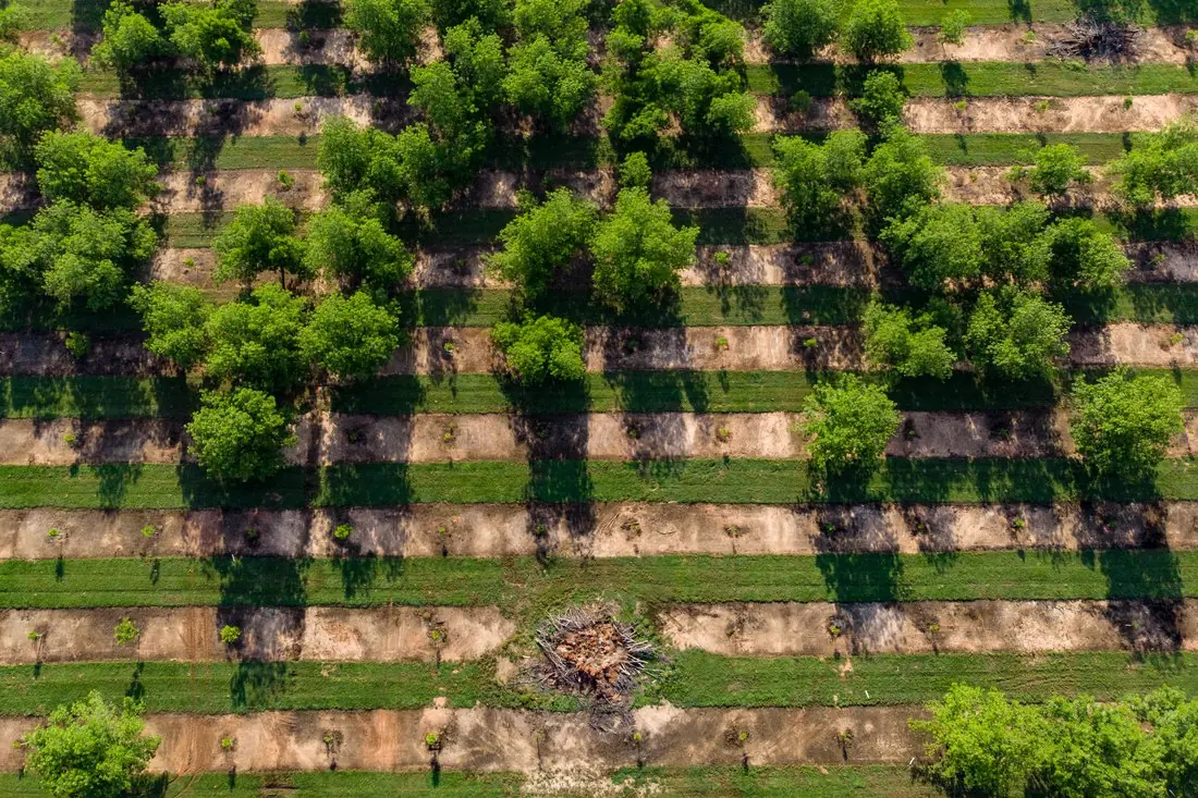
- Mature tree42 crowns
- Young tree53 points
- Debris pile2 polygons
What plant & tree counting labeling is
From 50–120 m above the ground a drone resolves single trees and young plants. We label each one, separate mature trees from young or replanted ones, and mark missing and dead positions in the planting grid, which is where yield and replanting decisions start. The example is a pecan orchard in Fort Valley, Georgia, two years after Hurricane Irma: surviving mature trees, young replacement trees on the strips and a pile of storm debris.
How we label it
Every tree or plant gets a point at its centre or a crown outline, with a class such as mature, young or dead. Where planting follows a grid, empty positions are marked as missing, so the count includes what is not there.
Who uses plant & tree counting labels
Stand counts
Exact tree and plant numbers per block for yield forecasts, insurance and sales.
Replanting
Missing and dead positions located, so replacement trees go exactly where the gaps are.
Counting models
Points or crowns labeled on your imagery to train models for the next flights.
Forestry plots
Seedling survival counts after planting, for forest owners and carbon projects.
How a project runs
Four steps, each ending in something you can check before the next one starts. The drone image annotation covers formats, quality checks and cost in more detail.
Brief
Area, dates and class list agreed in writing, with example images for every class and its edge cases.
You getWritten labeling guideline
Imagery
Your satellite or drone imagery, or satellite scenes sourced for you: free Sentinel and Landsat, or commercial high-resolution.
You getScene list with dates and resolution
Labeling
Annotators work to the guideline. Anything the imagery cannot settle is flagged, not guessed.
You getLabels plus a log of flagged cases
Check & delivery
Every class is reviewed against a sample before the data leaves us.
You getData and per-class accuracy, in your format and CRS
Questions about plant & tree counting
Can you count plants in dense crops?
Only where single plants can be told apart, for example in young row crops, orchards or nurseries. Where canopies close, we label crowns or cover instead of counts.
How do you handle overlapping crowns?
Each trunk position gets one point, and crowns are split along the visible gaps. Unclear cases are flagged.
Do you need multispectral imagery?
No. RGB is enough for counting. Multispectral helps to judge tree health, which can be added as a class.
Related label types
Need plant & tree counting labeled?
Tell us your area, your imagery and what your model has to learn. We reply with a proposed class list and a quote.