New construction labeling from satellite imagery
New construction labeling marks building sites, earthworks, reclaimed land and freshly built structures. Governments use it to catch building without permits and to keep tax and planning registers current; developers and investors use it to track progress.
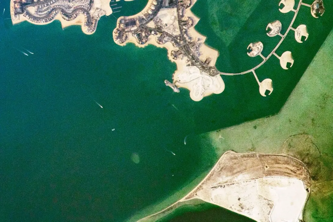
- Reclaimed land1 polygon
- Building plot (new)7 circles
- Completed district2 polygons
- New causeway1 line
What new construction labeling is
Construction goes through visible stages (cleared ground, foundations, structure, finished building), and each stage looks different from orbit. We label the stage, not just the presence of change, so a site can be followed over time. The example shows new islands being built off Doha: finished districts, building plots on new land and bare reclaimed ground.
How we label it
Sites are labeled as polygons with a stage class and the first date it was seen. Paired with building footprint labeling, finished buildings flow straight into the footprint layer.
Who uses new construction labels
Permit enforcement
Compare new construction against issued permits to find unpermitted building.
Property tax registers
Add new buildings to the register when they appear, not years later.
Development tracking
Follow construction progress across projects for planners and investors.
Change-detection models
Staged construction examples to train models that detect new building.
How a project runs
Four steps, each ending in something you can check before the next one starts.
Brief
Area, dates and class list agreed in writing, with example images for every class and its edge cases.
You getWritten labeling guideline
Imagery
Your imagery, or sourced for you: free Sentinel and Landsat, or commercial high-resolution scenes.
You getScene list with dates and resolution
Labeling
Annotators work to the guideline. Anything the imagery cannot settle is flagged, not guessed.
You getLabels plus a log of flagged cases
Check & delivery
Every class is reviewed against a sample before the data leaves us.
You getData and per-class accuracy, in your format and CRS
Questions about new construction
How early can construction be detected?
From the first earthworks: cleared or graded ground is usually visible before any structure.
Can you match sites to our permits?
Yes. With your permit locations, each site is tagged as permitted, not found in permits, or unclear.
What imagery do you recommend?
For single buildings, sub-metre imagery a few times a year. For large sites, Sentinel-2 every few days is enough to see progress.
Related label types
Need new construction labeled?
Tell us your area, your imagery and what your model has to learn. We reply with a proposed class list and a quote.