Solar panel inspection labeling from drone imagery
Solar panel inspection labeling marks every panel table, string or module in drone imagery of a solar farm and flags the ones with visible defects: hotspots, cracked glass, soiling, shading or vegetation. It is the training data for automated inspection and the defect list an operations team works through.
Also calledsolar panel annotation · PV inspection labeling · thermal solar defect annotation
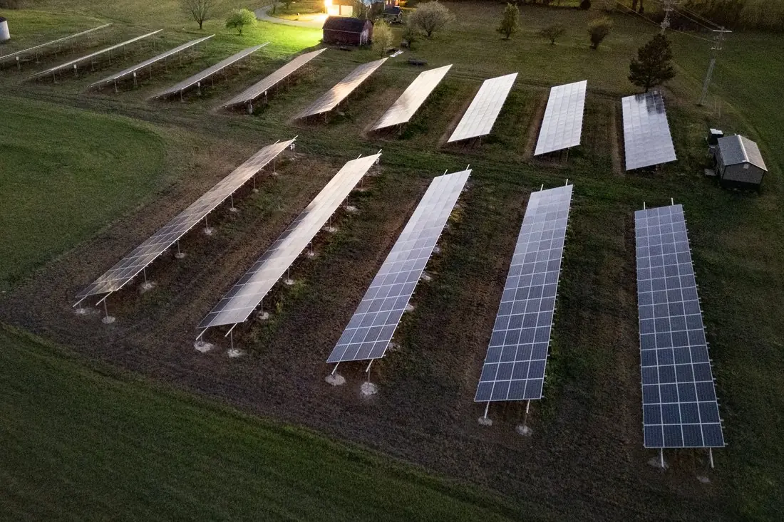
- Inspectable table4 polygons
- Glare: not inspectable11 polygons
- Equipment2 polygons
What solar panel inspection labeling is
Drone surveys are the standard way to inspect a solar farm: an RGB camera shows broken glass, dirt and vegetation, and a radiometric thermal camera shows cells running hot. We label both and keep them linked, so a hotspot can be traced to the exact module. Panels the imagery cannot judge (glare, motion blur, shadow) get their own class instead of a guess. The example is a drone photo of a small solar farm in Tennessee at dusk: rows with visible cells are inspectable, rows reflecting the sky are flagged.
How we label it
Tables or modules are outlined on the orthomosaic or on the single drone frames, and each gets a status from a written class list. Thermal anomalies are labeled against criteria agreed with you, for example the classes of IEC TS 62446-3 or a temperature difference to neighbouring cells.
Who uses solar panel inspection labels
Inspection models
Panels and defects labeled module by module to train detection models for the next survey.
O&M work orders
A defect list with locations, so field crews go straight to the modules that need cleaning or replacing.
Warranty and insurance claims
Defects documented per module, with the image as evidence.
Asset registers
Every table, string and module mapped once, as the base for later inspections.
How a project runs
Four steps, each ending in something you can check before the next one starts. The drone image annotation covers formats, quality checks and cost in more detail.
Brief
Area, dates and class list agreed in writing, with example images for every class and its edge cases.
You getWritten labeling guideline
Imagery
Your satellite or drone imagery, or satellite scenes sourced for you: free Sentinel and Landsat, or commercial high-resolution.
You getScene list with dates and resolution
Labeling
Annotators work to the guideline. Anything the imagery cannot settle is flagged, not guessed.
You getLabels plus a log of flagged cases
Check & delivery
Every class is reviewed against a sample before the data leaves us.
You getData and per-class accuracy, in your format and CRS
Questions about solar panel inspection
Do you need thermal imagery?
For electrical faults, yes: a failing cell or bypass diode shows up as heat, not as anything visible. RGB is enough for broken glass, soiling, shading and vegetation.
Can you label single drone frames instead of an orthomosaic?
Yes. Thermal inspection is often labeled on the original frames, which keep the temperature data, and the result is mapped back to the module layout.
What happens with glare?
Panels that reflect the sky or the sun cannot be judged. They are labeled as not inspectable so they can be flown again, never guessed.
Related label types

Need solar panel inspection labeled?
Tell us your area, your imagery and what your model has to learn. We reply with a proposed class list and a quote.