Power line and utility labeling from drone imagery
Power line labeling marks the parts of an overhead line in drone or aerial imagery (towers and poles, conductors, insulators, crossarms) and the vegetation that grows too close to them. It is the training data for automated line inspection and vegetation management.
Also calledpower line annotation · transmission tower detection · utility asset annotation
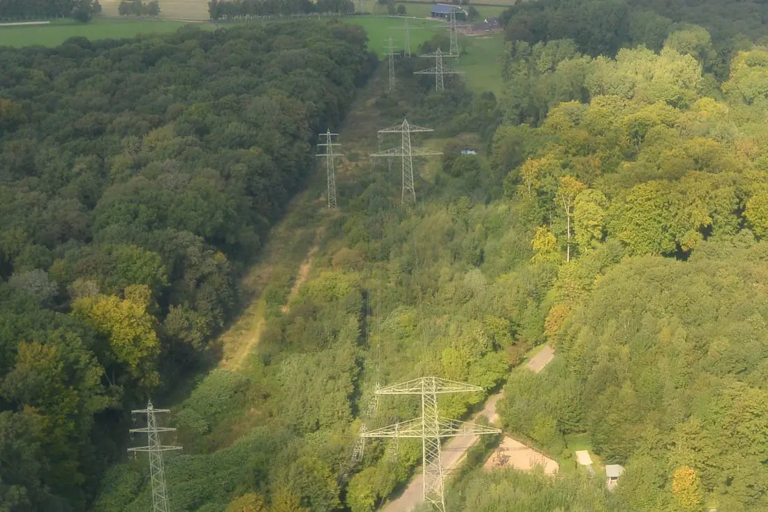
- Lattice tower9 boxes
- Conductor centreline2 lines
- Access track2 lines
What power lines & utilities labeling is
Utilities fly their lines with drones and helicopters to find damaged components and trees growing into the safety clearance. The labels follow the network: every structure gets an ID, conductors run from structure to structure, and close-up frames get component and defect labels. Where clearance has to be measured, we label LiDAR point clouds as well as photos. The example is an aerial photo of two high-voltage lines crossing a forest near Düsseldorf.
How we label it
Structures are labeled first and given IDs; conductors are drawn as lines between them, so the result forms a network. Component and defect labels are added on close-up frames. Vegetation is marked where it enters the clearance distance you specify.
Who uses power lines & utilities labels
Line inspection models
Towers, insulators and defects labeled for models that review thousands of inspection photos.
Vegetation management
Trees inside the clearance zone marked per span, so trimming crews go where they are needed.
Asset inventory
Every structure and span mapped with an ID and linked to the asset register.
Storm damage assessment
Fallen poles, broken conductors and trees on the line marked after a storm.
How a project runs
Four steps, each ending in something you can check before the next one starts. The drone image annotation covers formats, quality checks and cost in more detail.
Brief
Area, dates and class list agreed in writing, with example images for every class and its edge cases.
You getWritten labeling guideline
Imagery
Your satellite or drone imagery, or satellite scenes sourced for you: free Sentinel and Landsat, or commercial high-resolution.
You getScene list with dates and resolution
Labeling
Annotators work to the guideline. Anything the imagery cannot settle is flagged, not guessed.
You getLabels plus a log of flagged cases
Check & delivery
Every class is reviewed against a sample before the data leaves us.
You getData and per-class accuracy, in your format and CRS
Questions about power lines & utilities
Can clearance be measured from photos alone?
Only roughly. The distance between a tree and a conductor needs 3D data, so for clearance we label LiDAR point clouds or photogrammetric models.
Do you label close-up inspection photos?
Yes. Insulators, dampers, crossarms and visible damage are labeled with boxes or polygons on the original frames.
Does it have to be drone imagery?
No. The same labels work on helicopter and aircraft imagery; the example on this page is a photo taken from an aircraft.
Related label types
Need power lines & utilities labeled?
Tell us your area, your imagery and what your model has to learn. We reply with a proposed class list and a quote.