Construction site labeling from drone imagery
Construction site labeling marks what is on a building site in drone survey imagery: structures by construction stage, foundations, earthworks and stockpiles, machinery and site cabins. Repeated on every flight, it shows how the site progresses and where material is.
Also calledstockpile annotation · construction site annotation · earthworks monitoring
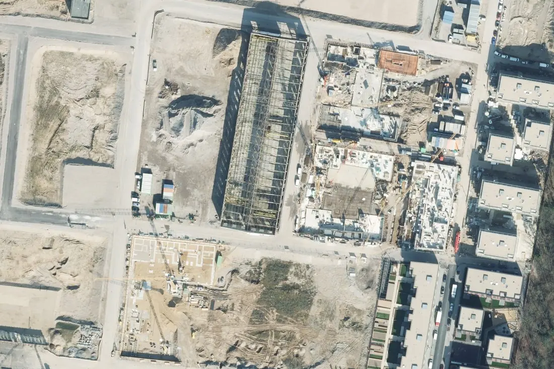
- Under construction7 polygons
- Foundation1 polygon
- Stockpile3 polygons
- Site cabin4 boxes
- Finished building9 polygons
What construction & stockpiles labeling is
Contractors and developers fly their sites weekly or monthly. Labeling the same classes on every flight turns the imagery into a progress record: which building reached which stage, how stockpiles grow and shrink, where machinery and materials stand. Stockpile volumes need elevation data, so piles are outlined on the orthomosaic and measured against the drone surface model. The example is a 10 cm survey image of the Clouth quarter in Cologne during construction in 2016.
How we label it
Classes and construction stages are agreed with you first (for example foundation, shell, roof, finished). Each structure is outlined and given its stage; piles, machinery and cabins get their own classes. Later flights are labeled against the same IDs, so changes can be followed object by object.
Who uses construction & stockpiles labels
Progress tracking
Structures labeled by stage on every flight, for reports to owners and lenders.
Stockpiles and earthworks
Pile outlines for volume calculation from the surface model, flight by flight.
Site analytics models
Machinery, materials and structures labeled to train detection models for site monitoring.
Permits and safety
Site cabins, fences and access routes mapped against the approved site plan.
How a project runs
Four steps, each ending in something you can check before the next one starts. The drone image annotation covers formats, quality checks and cost in more detail.
Brief
Area, dates and class list agreed in writing, with example images for every class and its edge cases.
You getWritten labeling guideline
Imagery
Your satellite or drone imagery, or satellite scenes sourced for you: free Sentinel and Landsat, or commercial high-resolution.
You getScene list with dates and resolution
Labeling
Annotators work to the guideline. Anything the imagery cannot settle is flagged, not guessed.
You getLabels plus a log of flagged cases
Check & delivery
Every class is reviewed against a sample before the data leaves us.
You getData and per-class accuracy, in your format and CRS
Questions about construction & stockpiles
Can you calculate stockpile volumes?
Volumes come from the drone surface model. We outline each pile and its base, so the calculation covers only the pile.
How often should a site be flown?
It depends on the project; weekly or monthly flights are common. Each flight is labeled against the same classes and IDs.
Can you use imagery from our own drone?
Yes. Orthomosaics from the usual processing software, for example DJI Terra, Pix4D or Agisoft Metashape, can be labeled directly.
Related label types
Need construction & stockpiles labeled?
Tell us your area, your imagery and what your model has to learn. We reply with a proposed class list and a quote.